Site Plan Rendering: How to Turn a Plan Into an Aerial View
Sep 22, 2026 · 12 min read
Site plan rendering explained: the three levels, what each costs ($149 to $799 a view), who buys them, and how AI turns a site plan into an aerial in a minute.
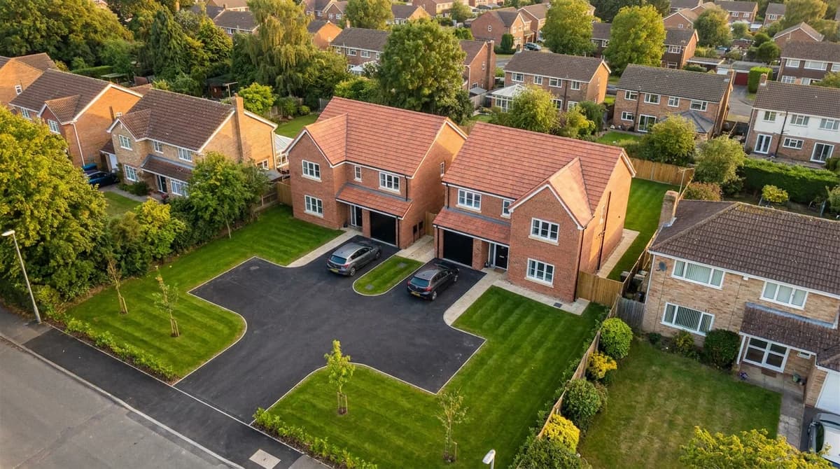
To turn a site plan into an aerial view, you have three routes: color the flat plan, build a 3D model and render it, or let AI render straight from the drawing. Site plan rendering costs from $149 for a colored plan to $799 for a studio aerial, or a few dollars and about a minute with AI.
A rendered site plan is a site plan given color, materials, shadows, or a full 3D treatment so that a buyer, planning commissioner, or investor can read it as a place instead of a diagram. The boundary, footprint, parking bays, and access stay where the architect drew them; lawn, paving, roof tiles, cars, and trees are added on top.
What Does a Site Plan Show, and Why Render It?
A site plan is "a type of drawing used by architects, landscape architects, urban planners, and engineers which shows existing and proposed conditions for a given area, typically a parcel of land which is to be modified," as Wikipedia puts it. Property lines, building outlines, driveways and parking, paths, utilities, and landscaping are drawn to scale with a north point.
That format is strict because the drawing is a legal record. The City of Portland asks for a site plan at 1 inch = 10 feet or larger, in black and white, with a north arrow and every existing tree of 12 inches or more listed by species. North Northamptonshire Council in England asks for 1:500 or 1:200, a north point, parking and turning, and boundary treatments.
That precision makes a raw site plan useless for selling. According to the National Association of Realtors, 97% of home buyers search for properties online, and photos are the primary factor in deciding whether to request a showing. A black-and-white plan is not a photo. Site plan rendering keeps the accuracy and adds the readability.
What Are the Three Levels of Site Plan Rendering?
Rendered site plans come in three levels of realism.
| Level | What it shows | When to use it | Typical studio price |
|---|---|---|---|
| 1. Colored 2D plan | Flat top-down plan with color fills for lawn, paving, and roofs, plus shadows and tree canopies | Committee boards, brochure plans, planting schemes | From $149 per plan (The 2D3D Floor Plan Company) |
| 2. 3D aerial (bird's-eye) | The plan tilted to a bird's-eye camera so buildings show height, roof form, and shadow, with simplified materials | Developer marketing, investor decks, phase plans | From $249 per plan, $149 to $779 by building count (The 2D3D Floor Plan Company) |
| 3. Photoreal drone-style aerial | A drone-style photo of the finished plot: real roof tiles, asphalt, parked cars, mature planting, finished neighbors | Portal hero image, site boards, off-plan launches | $799 per aerial, 5 to 6 days (Render3DQuick) |
Level one is the workhorse: still a plan, so it sits next to the technical drawing in a committee pack.
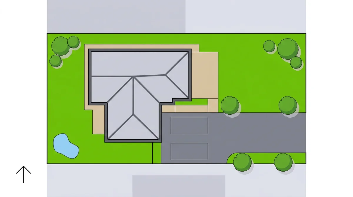
Level two adds height, so a buyer sees the garage is single-story and the house is two. Level three stops looking like a drawing, and it is the level AI has changed most.
Who Asks for a Rendered Site Plan?
Four groups order most site plan renders.
Planning committees and design review boards. Members who are not architects read a colored plan faster than a line drawing. The scaled drawing still gets submitted; the render goes on the slide.
Developers marketing plots and phases. RoomLift platform data for the 12 months to September 2026 shows property developers running about 47 generations per active user, against about 7.5 for real estate agents and 5.4 for homeowners, roughly 9x a homeowner's volume.
Agents and land brokers selling a site with permission. A plot with permission is sold on paper; at the gate the buyer sees grass. The National Association of Realtors reports that 81% of buyers say staging makes it easier to picture a property as their own, and an aerial render does the same job for a house that does not exist yet (see selling land with planning permission).
Landscape architects. A colored plan is the fastest way to show planting zones and retained trees. RICS found that listings with floor plans receive 30% more engagement than those without, and a rendered site plan is the outdoor equivalent.
Real estate media companies are a fifth, growing group: one more line on the invoice from files the client already has, as RoomLift for photographers shows.
How Do You Render a Site Plan? Four Methods Compared
Four routes trade time and skill against money.
| Method | Time | Cost range | Skill needed |
|---|---|---|---|
| Photoshop or Illustrator coloring | Hours per plan | Photoshop from US$22.99 per month (Adobe) | Medium: layers, fills, masks |
| SketchUp or Revit plus a render engine | Days: model, light, render | SketchUp Pro from $33.25 per month billed annually (Trimble), plus a render engine | High: 3D modeling, materials, lighting |
| Visualization studio | 2 to 5 business days per site plan (The 2D3D Floor Plan Company); 5 to 6 days per aerial (Render3DQuick) | $149 to $779 per 3D site plan (The 2D3D Floor Plan Company); $799 per aerial (Render3DQuick) | None: send the drawings |
| AI from the drawing (RoomLift Drawing to Aerial) | Under 60 seconds | About $1 to $5 per image (RoomLift) | Low: export an image, pick a preset |
The do-it-yourself routes cost little beyond the subscription, but every revision means redoing the fills or re-rendering the model; our architectural rendering software comparison covers the engine choices.
A studio removes the skill barrier and adds a wait: Render3DQuick lists aerials at $799 each on 5 to 6 days, and freelance rates of $50 to $150 per hour. AI from the drawing is the newest and cheapest route: you upload a picture of the plan, not a model, and the software adds materials, light, and planting while keeping the drawn geometry.
How Do You Turn a Site Plan Into an Aerial in a Minute?
The workflow with RoomLift's Drawing to Aerial preset, part of the Drawing to Render toolset for planning packs:
Step 1: Export the site or block plan as an image. Use a JPG, PNG, or WebP at the highest resolution you have. RoomLift reads images, not model files, so a .dwg, .rvt, .skp, or PDF must be exported to a picture first.
Step 2: Choose Drawing to Aerial. Upload the image and pick the preset. Its siblings are Drawing to Render, for an architect's 3D view, and Plan to Dollhouse, which needs a 3D cutaway floor plan image rather than a flat 2D plan.
Step 3: Paste the materials schedule. Copy the materials and finishes schedule from the design pack into the prompt, or upload the design details sheet, so the render uses your roof tile, brick or render color, and paving instead of inventing its own.
Step 4: Generate and download. In about a minute you get a photoreal aerial of the finished plot: cars in the marked bays, planting where greenery is drawn, asphalt on the drive, and neighboring houses finished to match. Output goes up to 4K, and each image costs about $1 to $5 in credits (RoomLift). New accounts get 5 free renders on signup.
Drag the slider to see a white site render become a drone-style aerial:
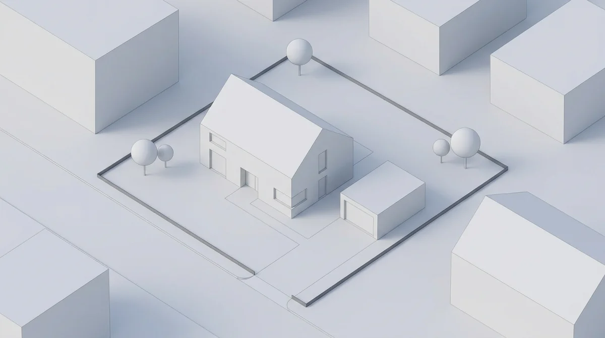
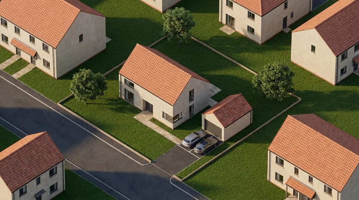
Label the result as a computer-generated image wherever you publish it, as a brochure labels an architect's CGI.
What Must a Good Aerial Keep, and What May It Not Change?
An aerial render is only useful if it is still a picture of the approved scheme: lay the plan over the render and every drawn element should sit in the same place.
What it must keep:
- The site boundary. The red line is the plot. A different fenced shape is a different property.
- The building footprint and count. One house and one garage on the plan means one house and one garage in the image, same size and position.
- The parking layout. North Northamptonshire asks for parking and turning on the plan itself, so a render that adds a third bay misrepresents the approval.
- Orientation. North stays north, and the house faces the street it faces on the plan.
- Trees where drawn. Portland lists every existing tree of 12 inches or more by species and position, so those circles are not decoration.
What it may not change: the house's position or rotation, the number of stories, the roof form, the drawn access, or a neighboring building that exists.
What it may add: materials, daylight, cars, planting, and finished neighboring houses. Neighbors are filled in plausibly, not surveyed, which is one reason the output is a marketing visual, not a planning-accurate drawing; dimensions come from the architect's pack.
Have a site plan and a materials schedule? Upload the plan image to RoomLift, choose Drawing to Aerial, and get a photoreal aerial of the finished plot in about a minute. 5 free renders on signup.
Stage your first room in 20 seconds. No design skills needed.
How Much Does Site Plan Rendering Cost?
Site plan rendering is priced by level and by who does it.
| Deliverable | Studio price | Turnaround | AI from the drawing |
|---|---|---|---|
| Black-and-white 2D site plan | From $99 (The 2D3D Floor Plan Company) | 2 to 5 business days | Not needed |
| Colored 2D site plan | $149 to $479 by building count (The 2D3D Floor Plan Company) | 2 to 5 business days | About $1 to $5 per image (RoomLift) |
| 3D site plan rendering | $149 to $779 by building count (The 2D3D Floor Plan Company) | 2 to 5 business days | About $1 to $5 per image |
| Photoreal aerial | $799 each (Render3DQuick) | 5 to 6 days | About $1 to $5 per image, under 60 seconds |
For context, MyArchitectAI puts the wider market at $250 to $2,800 per residential still, and RoomLift's own comparison is a traditional render at $200 to $500 against about $1 to $5 for AI; see our architectural rendering cost guide.
A drone shoot of a finished property costs $150 to $300 at intermediate level and $300 to $500 or more from a professional (PhotoUp), but a drone cannot photograph a house that has not been built. For a plot with permission the choice is a studio aerial at $799 or an AI aerial at a few dollars, and AI pricing does not climb with building count.
Frequently Asked Questions
What is a rendered site plan?
A rendered site plan is a site plan given color, materials, shadows, or a full 3D treatment so that non-technical viewers read it as a place rather than a diagram. The drawn boundary, footprint, parking bays, and access stay put; lawn, paving, roofs, cars, and planting are added on top of them.
How much does site plan rendering cost?
The 2D3D Floor Plan Company lists a black-and-white 2D site plan from $99, a colored one from $149, and 3D site plans at $149 to $779 by building count, on 2 to 5 business days. Render3DQuick lists aerials at $799 each on 5 to 6 days. AI from the drawing costs about $1 to $5 per image and takes under 60 seconds (RoomLift).
What is the difference between a 2D site plan render and a 3D aerial render?
A 2D site plan render is the flat, top-down plan with color fills for lawn, paving, roofs, and water. A 3D aerial render tilts the camera to a bird's-eye angle so buildings show height, roof shape, and shadow. The 2D3D Floor Plan Company lists colored 2D plans from $149 and 3D aerial site plans from $249; a photoreal drone-style aerial costs more.
Can I use a rendered site plan in a planning application?
No. A rendered site plan is a marketing visual, not a planning-accurate drawing. Authorities want a scaled line drawing: Portland requires 1 inch = 10 feet or larger in black and white with a north arrow, and North Northamptonshire Council asks for 1:200 or 1:500 with a north point. Submit the architect's drawing and use the render for the brochure or committee slide.
How do I turn a site plan into an aerial view with AI?
Export the plan as a JPG or PNG, upload it to RoomLift, choose Drawing to Aerial, and paste the materials schedule from the design pack. In about a minute you get a photoreal aerial, up to 4K, with cars in the marked bays, planting where greenery is drawn, and neighbors finished to match. New accounts get 5 free renders on signup.
What must an aerial render keep from the site plan?
It must keep the site boundary, the building footprint and count, the parking layout and number of bays, the access point, and the orientation. It may add materials, daylight, cars, and planting, but not move the house, add an undrawn driveway, or change the plot shape; if any of those shift, it is no longer a render of the approved scheme.
Sources & References
- Wikipedia. Site plan.
- City of Portland. Drawing a site plan.
- North Northamptonshire Council. Plan and drawing requirements.
- The 2D3D Floor Plan Company. 2D and 3D Site Plan Rendering Services and Site Plans/Maps pricing.
- Render3DQuick (2026). 2026 Cost of Renderings: 3D Visualization Price Guide.
- MyArchitectAI (2026). 3D Rendering Cost in 2026.
- PhotoUp (2026). Drone Real Estate Photography Pricing in 2026.
- Trimble. SketchUp plans and pricing.
- Adobe. Photoshop plans and pricing.
- National Association of Realtors. Profile of Home Staging and Profile of Home Buyers and Sellers.
- RICS. Royal Institution of Chartered Surveyors.
- RoomLift platform data, 12 months to September 2026, more than 10,000 AI generations.
Ready to transform your listings?
Stage your first room in 20 seconds. No design skills needed.